Owners of Waterfront Property Along the Strand
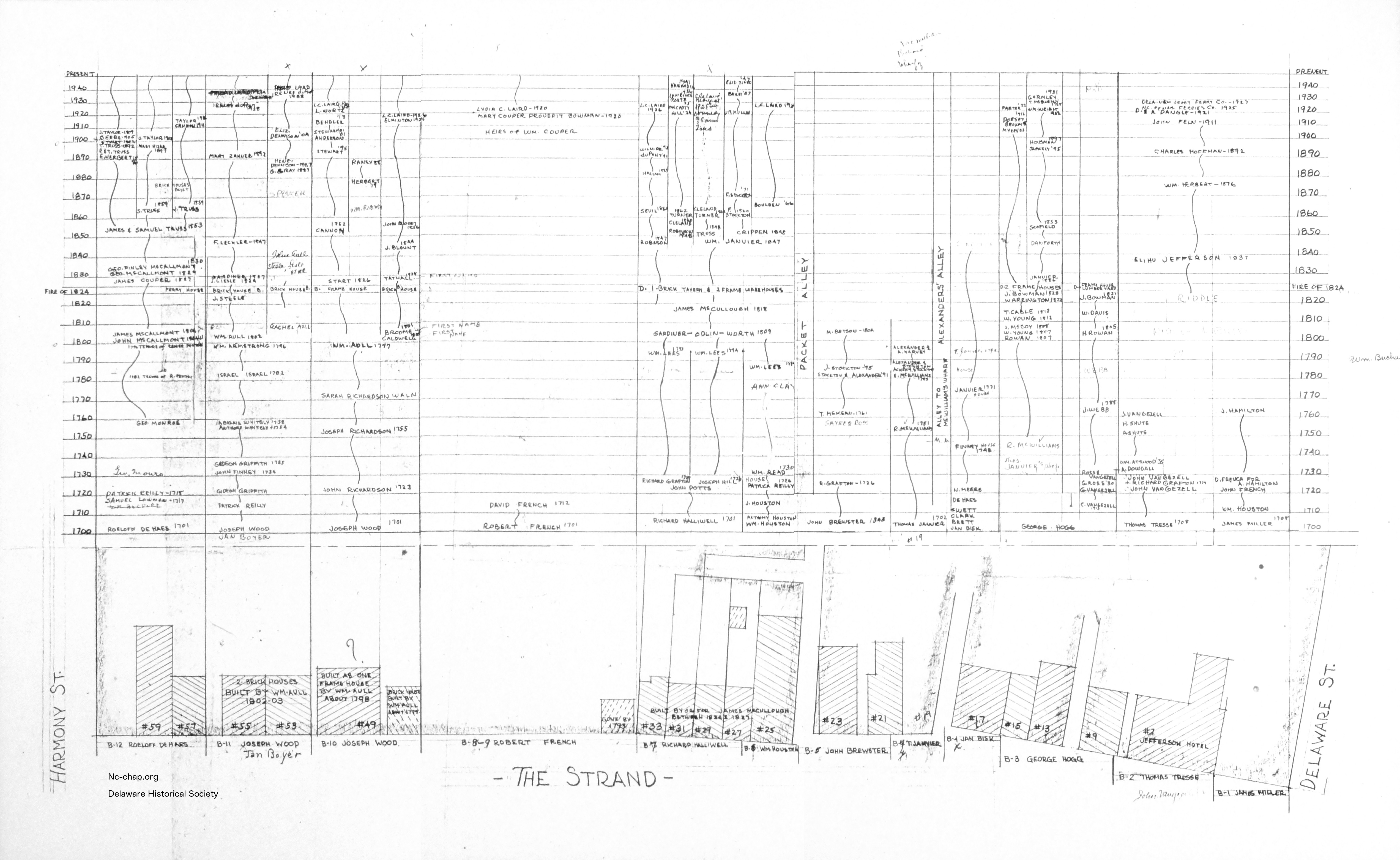
Courtesy Delaware Historical Society. Click on image to see full size. Click HERE for zoomable image.
While searching at the Delaware Historical Society in the folder about his house, Bob Poskitt found an amazing image.
The unknown author compressed into a single image a huge amount of information on the ownership of the waterfront properties on The Strand in New Castle over 240 years -- from 1700 to 1947.
Curious which six waterfront properties the Lairds owned after they bought the Read House? It's readily visible.
Which 4 buildings did the Aulls construct c1800? They're readily visible.
Note that building outlines at the bottom are of modern houses, and the names are presumably owners, not necessarily occupants, and that some data is missing (like at the site of the Stockton House (Duncan Residence).
Jeannette Eckman wrote about the waterfront:
Penn began to assign plots on the east side of the Strand In 1701. Each lot owner on the west side might apply for and receive a "bank lot", equal in breadth to his home lot and extending back 600 feet into the river, on condition that within seven years he would have a good wharf on his plot and would meanwhile improve the land. Fifty feet was to be allowed for the street between the home lots and the bank lots.
In the early eighteenth century there was a row of dwellings on the bank lots, some with shop in front or beside them, and with storehouses behind and wharves far out for landing and mooring of the owners' small vessels and of incoming ships. For individual houses and sites, see the detailed sections of this report.
AND
The shore in front of the earliest Strand dwellings would be the natural mooring place for the canoes, shallops and other craft belonging to the householders. Convenience would suggest wooden landings, and substantial wharfs for those who could afford them, or had the time end energy to build. Several early travelers describe the ground surface of New Castle as "stony" - and stones gathered from the fields would be cheap materiel for improving the wharfs and building bulkheads and walls to prevent damage by tides and storms.
In 1701, owners of houses on the Strand requested of William Penn, legal deeds for the "bank lots" in front of their houses. The grants were made, of equal width to the householder's property on the east side of the Strand and extending 600 feet from the street into the river. The warrants directed that the Strand should be fifty feet wide. A condition in the deeds was that the lots be improved and a good wharf built on each within within years from the date of the deed.
Between 1701 end l708 the lots between Delaware end Harmony Streets had been surveyed and the deeds recorded. Some Strand properties and the bank lots with them had changed hands in this period, some with mention of buildings and appurtenances on the bank lots. Deeds and wills for subsequent changes of ownership of property on the east side of the Strand continue to mention dwellings that faced the Strand, also shape, storehouses, and wharfs behind them end alleys between. The depth of the lots "600 feet into the river" as directed by Penn's warrants grant seem not to have extended their wharfage as the channel receeded A reliable eye-witness, Joshua Ramstead of Connecticut, wrote in his diary September 1749, while visiting New Castle that the fine compact town, handsomely situated an the Delaware River had "no wharf but what was dry at low water round it.
James L. Meek '13
NC-CHAP
NC-CHAP