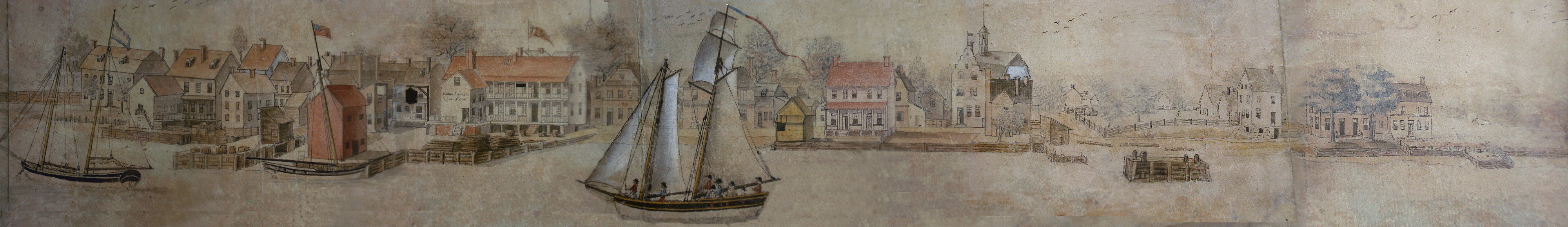
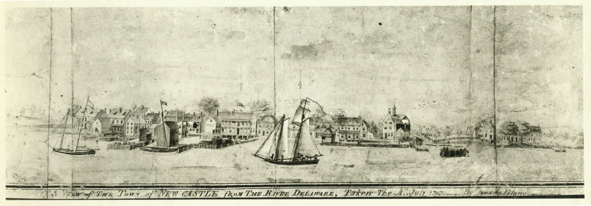
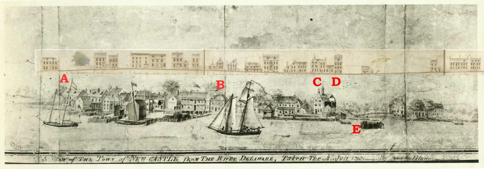
"A View of The Town of New Castle From The River Delaware,
-- Taken the 4th July 1797 -- By Ives le Blanc"
We can get a clear idea of what New Castle actually looked
like around 1800 by looking at this watercolor by Ives le Blanc and the watercolor
of Front St. done just 7 years later by Benjamin Latrobe.
Since at least the early 1900's, the 11" x 30" le Blanc picture has belonged to the Bringhurst
family, former owners of
Rockwood .
The copy shown here was made by taking closeups pictures of the image in its frame and assembling
them digitally. A black and white version
(from the Rodney collection in the Historical Society of Delaware) is better able to show the complete
image with the inscription at the bottom.
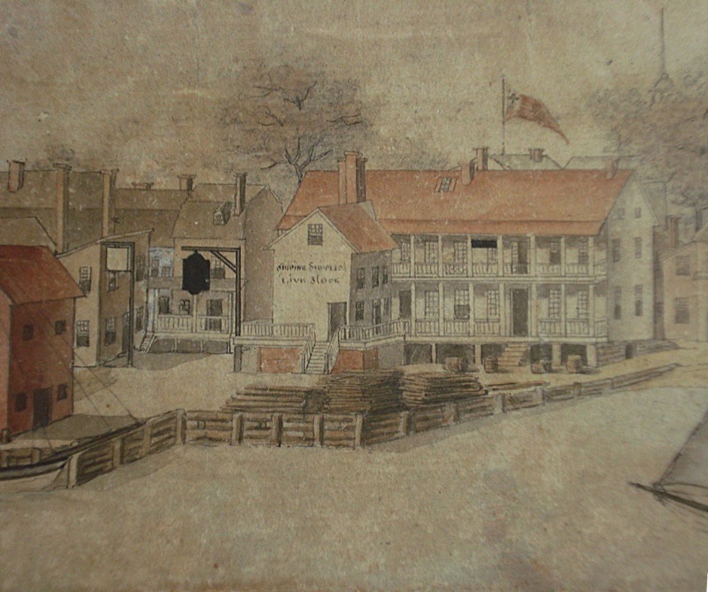
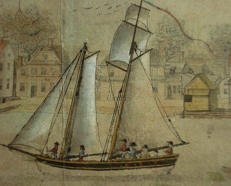
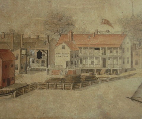 Noteworthy in the picture is the waterfront activity-- two schooners
(probably packet boats) entering and
leaving the harbor, and a shallop tied to Bond's wharf next to Packet Alley. On the wharf, in front of
Bond's store and the Stage Tavern, are piles of lumber; on the adjacent Alexander's wharf are
barrels (of rum?). The sign on the store (click to enlarge) appears to read
Noteworthy in the picture is the waterfront activity-- two schooners
(probably packet boats) entering and
leaving the harbor, and a shallop tied to Bond's wharf next to Packet Alley. On the wharf, in front of
Bond's store and the Stage Tavern, are piles of lumber; on the adjacent Alexander's wharf are
barrels (of rum?). The sign on the store (click to enlarge) appears to read
* -- for a town of 262
taxpayers! New Castle's real major activity was provisioning ships from
Philadelphia just before they started their voyage as reported by eyewitnesses.
 George Read Sr.'s house is visible behind the sails of the boat. George Read Jr.'s house would be built a few years later replacing the houses immediatley to
the right. The boat appears to be carrying two female passengers and 2 children. Two of the four person crew appear to be African-American.
George Read Sr.'s house is visible behind the sails of the boat. George Read Jr.'s house would be built a few years later replacing the houses immediatley to
the right. The boat appears to be carrying two female passengers and 2 children. Two of the four person crew appear to be African-American.
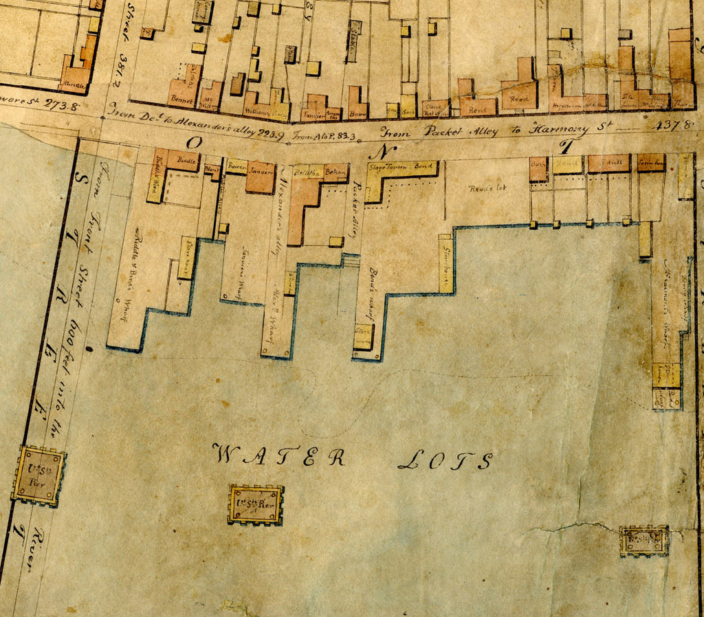
Many buildings are identifiable by shape or location, especially by comparing the picture with Latrobe's survey and view of Front Street. On the left are the Van Leuvenigh house (A), the Bond house (burnt 1824 and replaced as 30 The Strand) (B), the now-demolished Dutch Tile House (C) at 54 the Strand. The Thomas hotel (now the Episcopal parish house) (D), which is shown on the Latrobe survey had not been built in 1797. We see the Stage Tavern/Hotel/Bonds Store just to the left of Bond's house, with its many porches adjacent to Packet Alley, where Boulden Store now stands, the backs of buildings on the water side of The Strand, and the sheds, storehouses, and stores of an active waterfront. Then, the town was little more than a block wide.
* L. Riordan, Many identies, one nation, 2007
 Noteworthy in the picture is the waterfront activity-- two schooners
(probably packet boats) entering and
leaving the harbor, and a shallop tied to Bond's wharf next to Packet Alley. On the wharf, in front of
Bond's store and the Stage Tavern, are piles of lumber; on the adjacent Alexander's wharf are
barrels (of rum?). The sign on the store (click to enlarge) appears to read
Noteworthy in the picture is the waterfront activity-- two schooners
(probably packet boats) entering and
leaving the harbor, and a shallop tied to Bond's wharf next to Packet Alley. On the wharf, in front of
Bond's store and the Stage Tavern, are piles of lumber; on the adjacent Alexander's wharf are
barrels (of rum?). The sign on the store (click to enlarge) appears to read
Shipping Supplies
Live stock
Although
harbor traffic may have decreased by 1800, in
1772 140,000 gallons of rum came through the townLive stock
 George Read Sr.'s house is visible behind the sails of the boat. George Read Jr.'s house would be built a few years later replacing the houses immediatley to
the right. The boat appears to be carrying two female passengers and 2 children. Two of the four person crew appear to be African-American.
George Read Sr.'s house is visible behind the sails of the boat. George Read Jr.'s house would be built a few years later replacing the houses immediatley to
the right. The boat appears to be carrying two female passengers and 2 children. Two of the four person crew appear to be African-American.
Many buildings are identifiable by shape or location, especially by comparing the picture with Latrobe's survey and view of Front Street. On the left are the Van Leuvenigh house (A), the Bond house (burnt 1824 and replaced as 30 The Strand) (B), the now-demolished Dutch Tile House (C) at 54 the Strand. The Thomas hotel (now the Episcopal parish house) (D), which is shown on the Latrobe survey had not been built in 1797. We see the Stage Tavern/Hotel/Bonds Store just to the left of Bond's house, with its many porches adjacent to Packet Alley, where Boulden Store now stands, the backs of buildings on the water side of The Strand, and the sheds, storehouses, and stores of an active waterfront. Then, the town was little more than a block wide.
In the harbor (E) off Harmony Street wharf is one of the ice piers built by public subscription in 1794, then ceded to the Federal goverment in 1803.
|
 |
* L. Riordan, Many identies, one nation, 2007