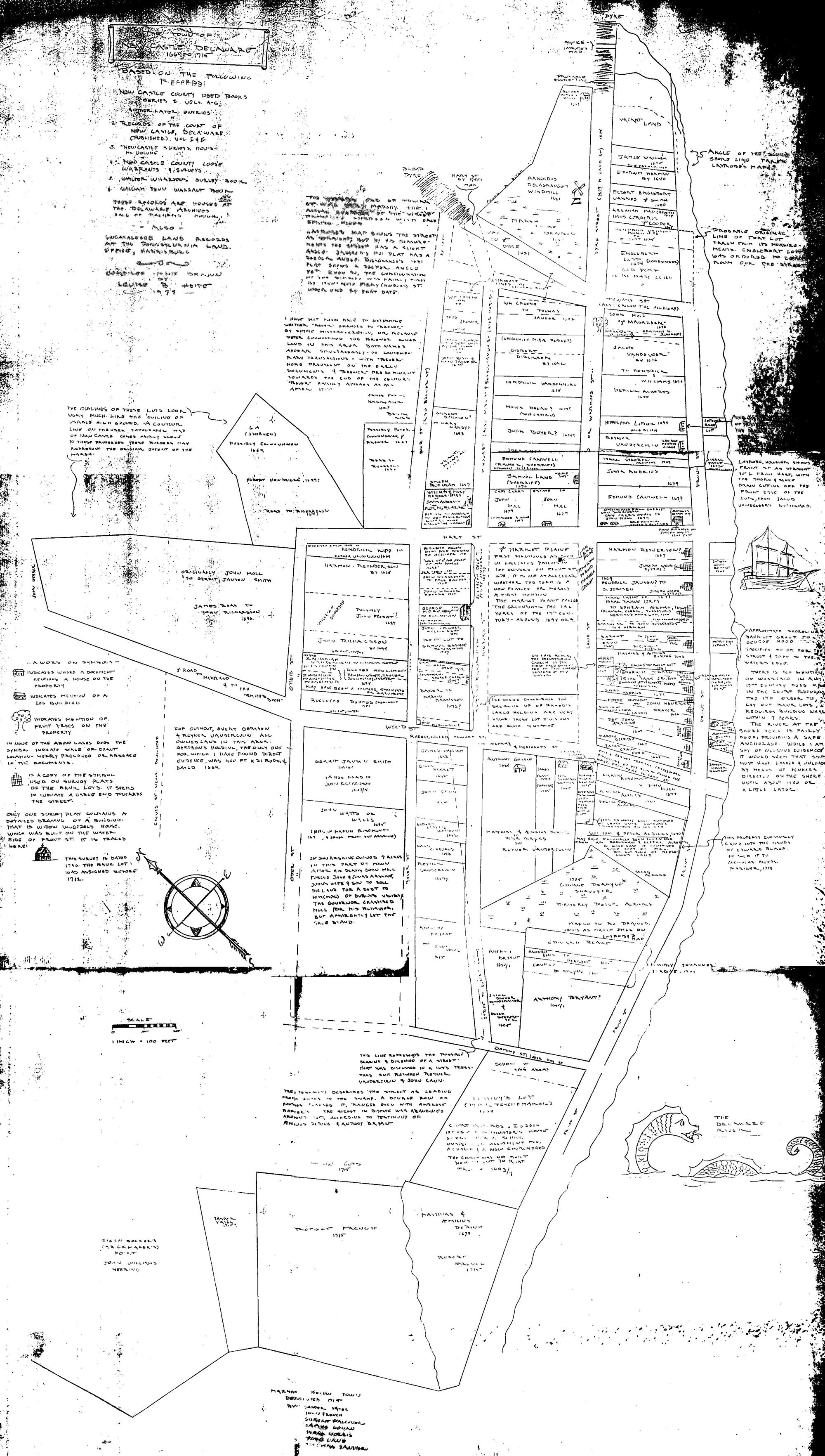
HARMONY STREET
An "old Dutch map" referred to in the Duke of York's period, 1664 to
1681, and later during the Penn period beginning in 1682, seems to have
established rights of way or "streets" between the Strand and the road-
ways before the houses on the west edge of the town - now Third, Fourth
and Fifth Streets, at that time known as Minquas or Mink, Beaver, and
Otter Streets. The street that is now Harmony was known both as Harte
and Mary Streets, and the "street to the free wharf". It led back from
the wharf at the river side across the Strand, along the green, across
Minquas and Beaver Streets to Otter. The wharf was built to provide a
landing place for ships when the wharf of the old fort had been
undermined by storms. The new wharf was there in the Duke of York's
period and may have been started at the end of the Dutch period.

Along the north side of Harmony Street from near the Strand west to
Minquas or Third Street, was the large plot of meadows, orchard and
wooded ground belonging to Alexander D'Hinojossa the last of the Dutch
governors. When the English came in 1664, D'Hinojossa's plot was
confiscated and given to Captain John Carr, who became the English
commander on the Delaware. Carr received much other land including
additional marsh and meadow at the north end of town and a mile-wide
strip of river shore south of the town extending from "the great creek"
south of the Battery down to Tom's Creek. Having ample means, he bought
other property, and built on the part of his Harmony Street plot opposite
the site of Immanuel Church,   "a great house with kitchen and blockhouse."
He had another house down Harmony Street to the east of the "great house"
and to the east of what is now Second Street, which street was not then cut
through. Whether this house was there in D'Hinojossa's time or was built
by Carr cannot be determined with certainty from the surviving records, but
the indications are that it was a Dutch period house.

The blockhouse attached to Captain Carr's "great house" provided a
measure of defense in the early 1670's while arrangements dragged for
replacing the storm-weakened and delapidated fort with an adequate
blockhouse, in the center of the town. The governor, himself lived in the
town during part of those years. His house was at approximately the site
of Captain Carr's other house, east of present Second Street, and must
have been Carr's house, [According to Benjamin Ferris's History of the Early
Settlements, Lovelace's house was standing In the early 1800's and was of Dutch
architecture, built of brick, having over each window and door a low, eliptical
arch made of yellow bricks imported from Holland. These features are the same
as those of the Tile house.]

Here Colonel Lovelace was at home in September, 1672 when the
distinguished English Quaker, George Fox, and his companions rode on
their horses into New Castle. As they were riding about, seekIng adequate
accommodations for men and horses, which seemed to be lacking, Governor
Lovelace came out from his house, invited Fox to stay with him, and made
provision for the other Friends also, probably with the aid of Captain
Carr in his large establishment. A public meeting was hold at the governor's
house, to which, Fox writes in his journal, most of the people came. As
George Fox's report of his visit to the Delaware region undoubtedly had great
effect upon the dreams of William Penn, this visit of the Quaker missionary
and his fellow members of the Society of Friends, in their strange garb,
had significance for the future of New Castle. It would be remembered just
ten years later, when William Penn's ship arrived at the free wharf, and Penn
himself in a broad quaker hat like that of George Fox, walked up Harmony Street
to the Green, there to be given legal possession of the soil as the new governor
and proprietor.

The Green or "Market place where the bell hangs" was chosen in 1671 for the
new blockhouse, which was to defend the town against Indian attack, much
feared at the time, and also "for the public service as council house,
prison and for other public purposes The building of the blockhouse was
begun In 1671 or 1672, but was not finished until after 1675 when Captain
John Carr was dead.

Captain Carr's two houses with their plot of land, 120 feet deep along the
north side of Harmony Street, were bought by John Moll In 1675. Moll
complained in 1680, that Captain Cantwell had shown him by "the old Dutch
map" where a street 60 feet wide was to go through this property (present
Second Street). To this he agreed, but now, after cutting down his
apple trees, giving up the sixty-foot strip and fencing both sides of the
street, his quit rents were doubled.

Plans for building a court house after William Penn came, dragged as had
those for the blockhouse in the 1670's. In 1689, Penn ordered the bounds of
the Green or Market Plains established and a warrant was issued for
surveying a lot for the court house. The survey excluded the blockhouse
site, which was conveyed first to Robert French about 1694. Later it was
bought by Jasper Yeates from whom it was acquired by the builders of
Immanuel Church. (The years between the survey and the disposal of the
blockhouse site to private owners might place the building of the first
part of the court house definitely before 1694, except for the fact that
the courts had been accustomed to meet at taverns in the winter time anyway
and could have continued to do so after the blockhouse with its second-
floor court-room was abandoned.)

When the church was built in what was formerly the market street on the
edge of the green, and the church yard occupied the site of the former
blockhouse with its dungeon underneath and court-room above, Harmony Street
is referred to in bounds for property as "the street from the church to the
free wharf."

On the northwest corner of the Strand and Harmony facing the Strand, lived
Johannes deHaes, son of Roeloff. His plot adjoined at the back the smaller
Carr garden and house that became John Moll's.  Johannes, a small boy when
his father died about 1655, was a prominent citizen in Penn's time. He had
inherited his mother's property including the plantation later known as
Monkbarus (the Janvier place near the Broad Dyke recently, 1946, sold for a
housing development). On the opposite corner where Immanuel Church house
(Thomas House) now is, his son, Roeloff II, owned a house and lot in the
early 1700's and at the other end of the block at Harmony and the Green,
his daughter Rebecca inherited from him a similar plot which she and her
husband sold to Patrick Reilly of the Tile house. On it had long been a
stable. Near Roeloff's house, on the south side of the street, stood "the
little brick house" of Colonel John French.

Governor Lovelace, in the eventful year for New Castle, 1672, made the
town a "corporation" by the name of a balywick, to be governed by a
bailey and six assistants. The bailey's position was that of deputy
governor and chief justice; his assistants were the justices who formed
the court. Their jurisdiction included "all the plantations upon the
Delaware river" and this new government was to establish English laws
instead of the Dutch procedure which had so far continued. But the order
was softened by the Governor's added statement, "according to the desire
of the inhabitants."

The new government was hardly under way when Dutch conquest abroad
returned the Delaware river region to the Dutch. Governor Lovelace went
back to England; the Dutch governor, Anthony Colve, put Peter Alrichs in
command at Now Castle, with orders that a substantial new fort must now be
built and that meanwhile all taxes were abolished!

In November, 1674, the English were back in control and governor Edward
Andros was appointed to continue the Duke of York's rule. It was during
this whole period that Harmony Street was the center of traffic, the
residence site of commanders, judges and some of the leading citizens,
the traffic way to the new site of fort and government building on the
green, of the hauling of supplies from the free wharf, of incoming
personages, settlers, traders and other visitors. When the court house
was built on the opposite side of the green, Harmony Street was less
lively, except on Sundays when Presbyterians and Episcopalians in their
Sunday best passed each other on the way to their separate places of
Worship.

For history of separate houses and buildings, see detailed sections of
this report.