
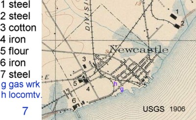
Click on map to see enlarged full map. Courtesy Louise B. Heite
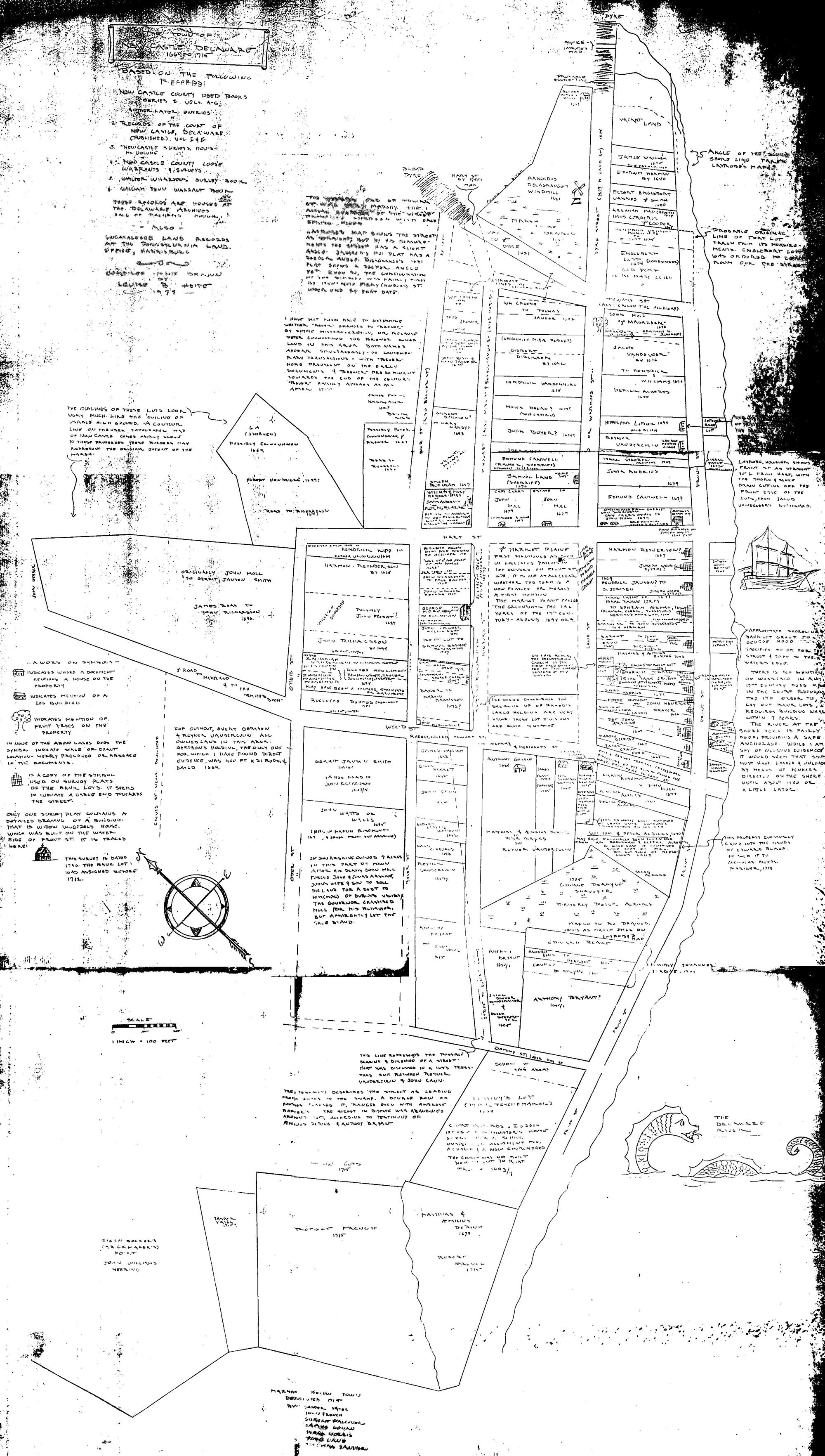
 New Castle's Dutch heritage is visible but not in any buildings.
What CAN be seen is the original layout of streets and blocks, and to a very small extent,
traces of the property lines.
New Castle's Dutch heritage is visible but not in any buildings.
What CAN be seen is the original layout of streets and blocks, and to a very small extent,
traces of the property lines.
Louise Heite pointed out in her 1978 thesis from the University of Delaware (p 13, 51)that existing Dutch titles and properties were honored when the English took over, and then again when Penn took over from the Duke of York's men.
Although she modestly claimed it was simple to assemble the property descriptions into a single map, her work required acquiring the property records prior to 1720, and making sense of the old descriptions, then assembling the whole thing.
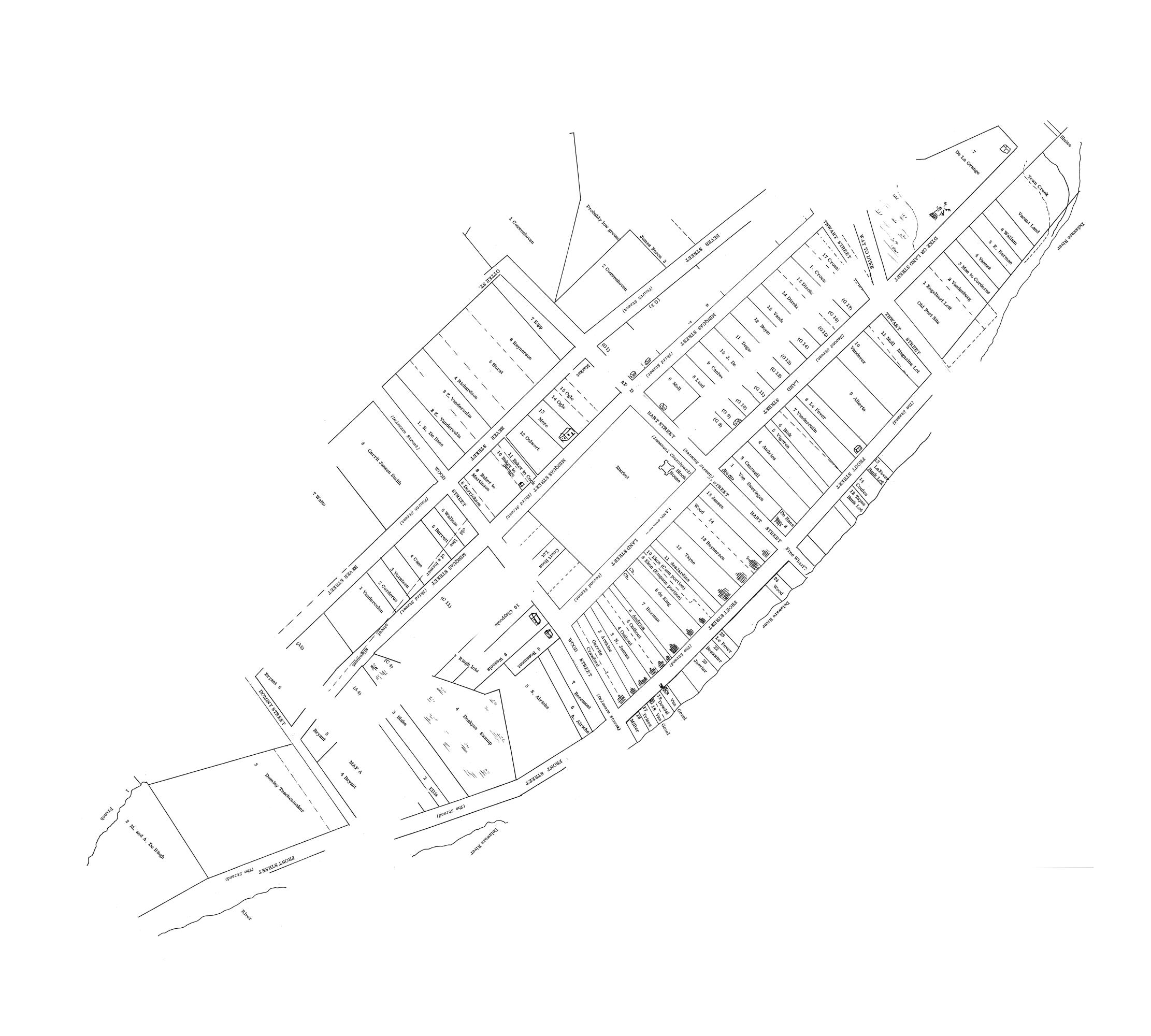
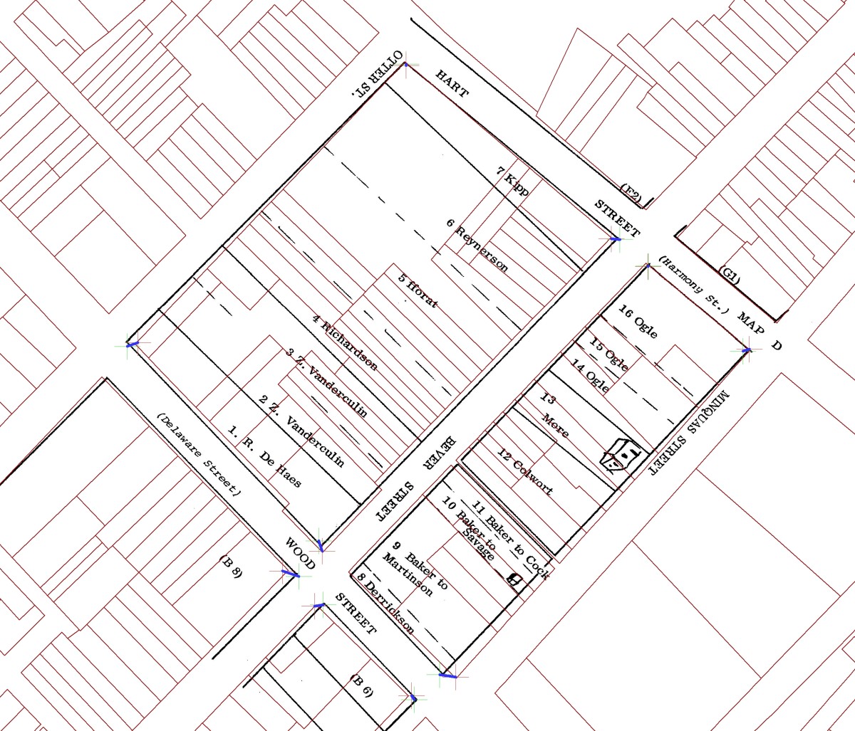
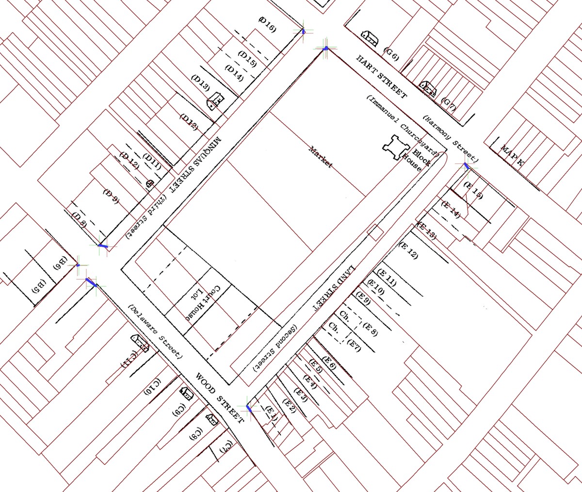
Click on the sketch map to see the maps she created, or the 'Pages" entries in the table below to see the individual records.
For convenience in access we reproduce her work here (with her permission) in the original format. We also make availabe overlays of the maps over 2008 county tax parcel maps, the Penn census from 1683-1687, all the individual property records in a single sortable table, a list of the first purchases for each lot, and Heite's hand drawn overview sketch (courtesy Cindy Snyder, DHCA)
Among the observations by looking at at the data:
* The town was SMALL in 1680. A composite map shows perhaps 5 blocks. One of these (modern fourth street) was probably essentially rural.
* Development was minimal on the water side of the Strand before 1700, and non-existant on the side of 2nd street where the Presbyterian Church now stands.
* Lot sizes were large in rural areas like 3rd and 4th streets and have been since heavily subdivided
* Modern street outlines match those in 1680 for The Strand, Delaware, 3rd and Harmony streets.
* The block now occupied by The Green seems to have been significantly larger, and may have extended over the market area.
* Occupations of landowners include both skilled trades: brickmaker, carpenter, cordwainer (shoemaker), cooper, smith and tanner, and white collar occupations: agent, attorney, merchant, minister. There was not a pronounced difference in where they plied their trades. If cordwainer Andrew Cock (a worker with soft (cordovan) leather) had a tannery on site, the remote location (A-2) was probably appreciated. Tannerys existed in New Castle as late as the Latrobe Survey of 1804. One is shown at the corner of 4th and South streets, next to the current fire station.
* 100 lots are listed, the first (H-4) granted in 1657 to Luke Dirckson. By 1670, 1680, 1690, and 1700 respectively, 11, 39, 61 and 78 lots had been granted . The lots granted prior to 1670 spanned much of the area: C-5, D-7, E-1, E-13, E-15, E-2, E-9, F-1, H-4, H-9, K-1
* The land belonging to Dominy [Reverend] Peter Teschenmaker in section A and even the street seems to have taken on the owner's name.
* Some family names are the same as in the parent colony of New Amsterdam, and either had emigrated, or were relatives (Herman), or were perhaps non resident owners (e.g. Gov. Penn). For example, Peter Couwenhoven was a brewer/schout (sheriff) in New Amsterdam. Ephraim Herman, surveyor, was the son of Augustine Herman from New Amsterdam, who then became Lord of Bohemia Manor in Maryland.
* Some family names such as deHaes, Deakyne and Janvier from this period persisted in New Castle into the 20th century.
* The locations of the windmill (J-7) and the old fort (Casimir) (J-1) are described here, and in more detail in the Ned & Louise Heite archaeological report on Fort Casimir. There is no mention of Bull Hill (or Mr. Bull) which would correspond to J-7. Bull Hill was leveled to provide fill for the ferry terminal (and thereby cover the site of Ft. Casimir).
* Street names changed: Front - Strand, Land - Second, Wood - Delaware (it ran to the woods), Hart - Harmony, Thwart - Chestnut (it crossed the main water front and land streets), Minquas - Third, and finally, Bever now Fourth street. According to the hand drawn map, this was alternately spelled Brever and Brewer, perhaps because of brewer Peter Couwenhoven. Whether there actually was a brewery on his property is not clear. Hendrick Kipp (Kypp), lot D-7 at the corner of Harmony and Bever was also a brewer in 1663 according to Scharff(1888).
See also Pennsylvania Land Records
New Castle parcel map c1680
Property descriptions and maps assembled by Louise B. Heite
New Castle's Dutch heritage is visible but not in any buildings.
What CAN be seen is the original layout of streets and blocks, and to a very small extent,
traces of the property lines. Louise Heite pointed out in her 1978 thesis from the University of Delaware (p 13, 51)that existing Dutch titles and properties were honored when the English took over, and then again when Penn took over from the Duke of York's men.
Although she modestly claimed it was simple to assemble the property descriptions into a single map, her work required acquiring the property records prior to 1720, and making sense of the old descriptions, then assembling the whole thing.
Click on the sketch map to see the maps she created, or the 'Pages" entries in the table below to see the individual records.
| Map | Pages |
|---|---|
| A | 78-81 |
| B | 83 - 85 |
| C | 87 - 94 |
| D | 96-101 |
| E | 103 - 112 |
| Map | Pages |
|---|---|
| F | 114 - 115 |
| G | 117 - 123 |
| H | 125 - 131 |
| J | 133 - 136 |
| K | 138 - 139 |
For convenience in access we reproduce her work here (with her permission) in the original format. We also make availabe overlays of the maps over 2008 county tax parcel maps, the Penn census from 1683-1687, all the individual property records in a single sortable table, a list of the first purchases for each lot, and Heite's hand drawn overview sketch (courtesy Cindy Snyder, DHCA)
Among the observations by looking at at the data:
* The town was SMALL in 1680. A composite map shows perhaps 5 blocks. One of these (modern fourth street) was probably essentially rural.
* Development was minimal on the water side of the Strand before 1700, and non-existant on the side of 2nd street where the Presbyterian Church now stands.
* Lot sizes were large in rural areas like 3rd and 4th streets and have been since heavily subdivided
* Modern street outlines match those in 1680 for The Strand, Delaware, 3rd and Harmony streets.
* The block now occupied by The Green seems to have been significantly larger, and may have extended over the market area.
* Occupations of landowners include both skilled trades: brickmaker, carpenter, cordwainer (shoemaker), cooper, smith and tanner, and white collar occupations: agent, attorney, merchant, minister. There was not a pronounced difference in where they plied their trades. If cordwainer Andrew Cock (a worker with soft (cordovan) leather) had a tannery on site, the remote location (A-2) was probably appreciated. Tannerys existed in New Castle as late as the Latrobe Survey of 1804. One is shown at the corner of 4th and South streets, next to the current fire station.
* 100 lots are listed, the first (H-4) granted in 1657 to Luke Dirckson. By 1670, 1680, 1690, and 1700 respectively, 11, 39, 61 and 78 lots had been granted . The lots granted prior to 1670 spanned much of the area: C-5, D-7, E-1, E-13, E-15, E-2, E-9, F-1, H-4, H-9, K-1
* The land belonging to Dominy [Reverend] Peter Teschenmaker in section A and even the street seems to have taken on the owner's name.
* Some family names are the same as in the parent colony of New Amsterdam, and either had emigrated, or were relatives (Herman), or were perhaps non resident owners (e.g. Gov. Penn). For example, Peter Couwenhoven was a brewer/schout (sheriff) in New Amsterdam. Ephraim Herman, surveyor, was the son of Augustine Herman from New Amsterdam, who then became Lord of Bohemia Manor in Maryland.
* Some family names such as deHaes, Deakyne and Janvier from this period persisted in New Castle into the 20th century.
* The locations of the windmill (J-7) and the old fort (Casimir) (J-1) are described here, and in more detail in the Ned & Louise Heite archaeological report on Fort Casimir. There is no mention of Bull Hill (or Mr. Bull) which would correspond to J-7. Bull Hill was leveled to provide fill for the ferry terminal (and thereby cover the site of Ft. Casimir).
* Street names changed: Front - Strand, Land - Second, Wood - Delaware (it ran to the woods), Hart - Harmony, Thwart - Chestnut (it crossed the main water front and land streets), Minquas - Third, and finally, Bever now Fourth street. According to the hand drawn map, this was alternately spelled Brever and Brewer, perhaps because of brewer Peter Couwenhoven. Whether there actually was a brewery on his property is not clear. Hendrick Kipp (Kypp), lot D-7 at the corner of Harmony and Bever was also a brewer in 1663 according to Scharff(1888).
James L. Meek '08
See also Pennsylvania Land Records